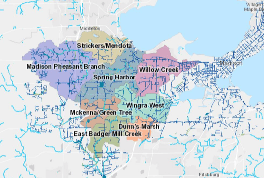
On the West side of Madison the city has started several studies to address the flooding issues. Here’s the info and some meetings you can attend to learn more.
The info below can also be found in this pdf. More information on these watershed studies can be found here. Some Watershed Study’s have their own websites.
Spring Harbor http://www.cityofmadison.com/engineering/projects/spring-harbor-watershed-study
Wingra West https://www.cityofmadison.com/engineering/projects/wingra-west-watershed-plan
Strickers/Mendota https://www.cityofmadison.com/engineering/projects/strickers-mendota-watershed-study
Madison Pheasant Branch https://www.cityofmadison.com/engineering/projects/madison-pheasant-branch-watershed-study
WATERSHED STUDIES OVERVIEW & CITYWIDE FLOODING PROGRAM
WHAT IS A WATERSHED
A watershed is an area of land that drains precipitation (rain, snow, etc.) to a common low point, such as an inlet, stream or lake. See page 4 for a map of the planned watershed studies in 2019.
WHY: NEED FOR THE STUDIES
There was extreme flooding in the last few years in the City of Madison. Not only are there more rain events, but more rain events where more than 3 inches fell during the storm. This caused extreme flooding and damage. The flooding also revealed ways we can improve our storm sewer. One way is to look at the watersheds as a whole, and then focus on specific ones that may need more immediate solutions.
IMPACT
Example: Aug. 20 storm caused substantial damage:
- There was $4 million in public infrastructure damage.
- There was $17.5 million in reported private property damage
- There was $30 million estimated in private property damage
PLAN OF ACTION
To find the problems and solutions, the City needs data and information. To educate the community, the Engineering Division, will hire consulting firms to model the stormwater and drainage system, provide alternative designs and cost estimates for those designs, and lead a series of Public Information Meetings about four watersheds the City will focus on. The Engineering Division will also contract with the US Geological Survey (USGS) to complete data collection and monitoring for rain events, which will be required to complete the system models.
MEETINGS
STRICKERS/MENDOTA WATERSHED PUBLIC MEETING
6-8 p.m., April 22, Asbury United Methodist Church, 6101 University Ave.
SPRING HARBOR WATERSHED PUBLIC INFORMATION MEETING
6-8 p.m., April 25, Madison Memorial High Auditorium, 201 S Gammon Rd.
WINGRA WEST WATERSHED PUBLIC MEETING
6-8 p.m., May 1, Cherokee Middle School Cafeteria, 4301 Cherokee Drive
MADISON PHEASANT BRANCH WATERSHED PUBLIC INFORMATION MEETING
10 a.m.-Noon, May 4, Edgewood College, Deming Way Campus, 1255 Deming Way, Room 150-153
SCHEDULE
- The first four watersheds being studied will kick-off the process. The City will host public informational meetings in April – May.
- The City will advertise for consultants for three additional watersheds (Willow Creek, Dunn’s Marsh and McKenna/Greentree) in early May and the projects will kick off in June. The City will work on an additional study in-house for the East Badger Mill Creek watershed, which will be conducted on the same schedule as the second round of consultant studies.
- Each study will take up to 18-24 months to complete. Additional public informational meetings and focus group meetings will be completed during this process to keep citizens and elected officials up to date on the study results.
- The Engineering Division will continue to budget for additional watershed studies for at least the next five years to have a comprehensive Stormwater and drainage model for the entire City.
BUDGET
The Engineering Division received Council approval for approximately $8M in funding for the Citywide Flood Mitigation program for 2019. This additional funding has increased the Stormwater Utility budget by 10.1%, which represents a $9.60 average residential increase for 2019. The additional funding will allow for the City to complete comprehensive flood studies, acquire lands, and complete construction for flood mitigation projects. It is anticipated that the watershed and flood studies will provide guidance on how to make systematic and thoughtful improvements to the drainage system over the course of the next several decades. Funding to continue improvements to the system will be included in future budgets. It is estimated that the City will continue to budget for $4M+ dollars in the Citywide Flood Mitigation Program in future years to support the flood mitigation efforts.
COMMUNICATION
The City got the word out a number of ways:
- News release
- Contact with specific groups (HOAs, tenant resource group, community organizations, etc.)
- Direct mailings to approximately 25,000 people for first 4 studies
- Printed posters in public libraries
- Facebook events for the watershed PIMs
- Updated its flooding website:
- New interactive map of watersheds
- Sandbag resource page
- Project pages for each watershed study to share progress
OTHER INITIATIVES
- Modifications to Chapter 37 of the Madison General Ordinances will be taking place in the next several month to better address flooding and requirements for new development and redevelopment.
- Flood Control Relief Remediation Plan – this is a plan that the Board of Public Works will approve which will define the City’s goals for flood mitigation and provide short, mid and long-term action plans to mitigate flooding.
- Policy for Resolving Private Drainage Problems on Private Property – this policy will be revised to help the Engineering Division resolve drainage problems on private property and lay out guidance for evaluation of the issues and if and how the City may fund or participate in solutions.


