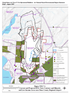
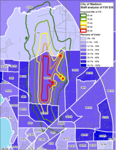
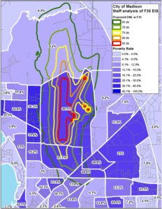
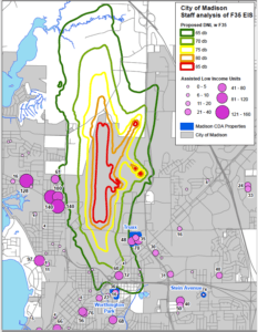
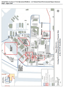
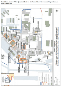
Here’s the city staff’s analysis of how F-35s will impact Madison, including more maps. The deadline for providing comments is Friday, September 27th. The full 1000-page draft EIS is available at http://www.angf35eis.com/Documents.aspx; the 40-page Executive Summary can be found here http://www.angf35eis.com/Resources/Documents/Draft_F-35A_EIS_Executive_Summary_August_2019.pdf. Everyone should provide comments!!!
To: Mayor Rhodes-Conway
From: Nan Fey, Interim DPCED Director
Date: September 10, 2019
Subject: F35 EIS Staff Analysis
This document contains staff’s analysis of the draft United States Air Force F-35A Operational Beddown National Guard Environmental Impact Statement (EIS) pertaining to the 115 Fighter Wing at Truax Field. Staff in the Planning Division, Community Development Division, Housing Authority, Engineering Division and Public Health of Madison and Dane County contributed to this report. Since this is not a City of Madison decision, staff is not providing a recommendation for or against the proposed location of F35s at Truax, did not evaluate sections of EIS document pertaining to other communities or compare impacts of various locations. The intent of this document is to provide a clear and objective compilation of relevant facts from the EIS and a greater explanation of how this could impact Madison for you and other elected officials who may wish to provide a comment to the Air National Guard as part of their review and decision process.
Comments can be made online at http://www.angf35eis.com/Comments.aspx through September 27 or at the
upcoming meeting on September 12 at the Exhibition Hall in the Alliant Energy Center starting at 5:30 pm.
Noise: Land Use and Neighborhood Impacts
As has been widely discussed, replacement of F16s with F35s would result in an increase in overall loudness in areas near Dane County Regional Airport and Truax Field.
The most discussed statistic in the EIS is Day Night Average Sound Level (DNL), a cumulative measure of multiple flights and engine maintenance that incorporates sound from both military and civilian aircraft. This metric is intended to provide an overall picture of noise exposures, rather than a measure of specific sound events. As a result, it isn’t directly comparable to other sound level statistics measured in decibels.
The DNL were calculated on a 500 ft. grid, which was then used to create sound contours (lines of equal sound exposure). These were generated by a model that factors:
• aircraft type and noise profiles
• number of flights for each aircraft type
• frequency of specific approach and departure paths (i.e. how often each runway is used)
In 1983, the FAA published Noise Control and Compatibility For Airports, an advisory document addressing
aircraft noise and surrounding land uses. The document established a standard methodology for measuring
cumulative noise exposure and identifies land uses that are often more sensitive to noise. Through this
document, the FAA determined the 65 db DNL contour is the noise exposure level where land use compatibility
issues may begin to arise surrounding airports. This document is the source of the land use compatibility table included in the draft EIS on page 3-33.
FAA’s advisory document appears tailored toward addressing future use of vacant property and redevelopments
surrounding airports by recommending land uses or construction techniques that minimize sound impacts to
users. It’s important to clarify that the document’s use of the term “Incompatible” does not mean
uninhabitable, nor is it a substitute for or superseding other local land use decisions. In effect, FAA designations of incompatible and conditionally compatible land uses with the 65db DNL curve defines where federal funding can be used to minimize and mitigate noise exposure for existing uses. The document also begins to discuss the Part 150 Noise Compatibility Program, which grants federal Airport Improvement Program funds to airports to carry out federally approved noise mitigation techniques. The Noise Compatibility Program will be discussed in greater detail later in this memo.
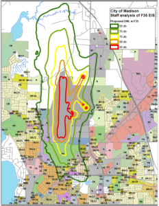
Current and Proposed 65 db Contours
The sound contour expansion is attributable to two primary factors: the change in sound level associated with the F35s and the increased number of flights planned. Because the sound contours are Day Night Average Sound Level, increased quantity flight events will increase the cumulative daily sound exposure and result in larger contours.
Long-term, flights are expected to increase from 2,400 to approximately 3,061 annually based on flight time
requirements and average flight length, a 27% increase. As part of the 115 FW’s alert mission function (rapid defense of domestic airspace), it would temporarily maintain additional F16 flights until the transition to an all F35 fleet is complete. During this transition time, flight activity could increase 47% from the current levels. The EIS doesn’t specify how long this transition period will be, but it does state the drawdown of F16s would approximately match the arrival of F35s. The delivery of F35s would occur in 2023 and 2024 so this may be the likely timeline for the additional flight activity. Staff has confirmed the modelling in the EIS is based on the temporary 47% increase. As a result, the long-term impacted area will likely be smaller than the geography shown.
Analysis of Population and Land Use In and Around the 65 db Contours
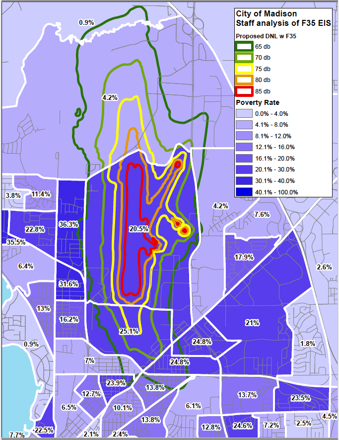
The EIS provides a basic level analysis of land use and the population that may be impacted within the 65 db curve. To do this, EIS authors manually counted residential structures and used 2016 American Community Survey 5-Year Census block group data to estimate impacted populations. The EIS estimated 1,318 households and 2,766 residents inside the 65 db curve. Demographic data was evaluated at the Census block group level by the EIS, including race/ethnicity, poverty and population under 18. The EIS used 20% of the population in poverty and 50% of the population identifying as a minority as thresholds to flag impacted block groups.
While the 50% minority rate may be a national standard for environmental impact statements, it appears to be a very high bar for measuring impacts on communities of color particularly in Madison and Dane County, where persons of color make up 26% and 20% of the population respectively. Using this metric, the only block groups flagged for having a minority population are west of the airport, generally outside the 65 db curve. Nearly every impacted area within the City of Madison belongs to a census tract with rates of persons of color well above the city- and county-wide averages. The block group with the largest expansion of the impacted area (Carpenter Ridgeway) is comprised of 43.9% persons of color. While the EIS acknowledges it has a disproportional impact on persons of color, its methodology results in this issue being understated.
The threshold for poverty appears more in line with Madison (26%) and Dane County (20%) averages. Like the
persons of color statistic above, nearly every block group within the impacted area has poverty rates above
the city-wide average.
It should also be noted that there are several concentrations of poverty and persons of color just outside the 65 db contour, including the CDA Truax housing, CDA Webb-Rethke townhomes and other housing near Worthington Park, and near the intersection of Packers Avenue and Northport Drive. While these areas will experience virtually identical noise exposure as residents who live on the contour line, they will not be eligible for federal sound mitigation funding through the Noise Compatibility Program. If Truax is selected for future F35s, it’s a reasonable conclusion that non-mitigated areas immediately adjacent to but outside the 65 db contour may experience more significant impacts than mitigated (soundproofed) residences inside the impacted area.
Rents and home values inside the 65 db contour are significantly more affordable than the City as a whole. Assessments of homes and condominiums inside the impacted area have a median value of $174,400 compared to the Madison median of $254,900. Rents are generally 10-20% lower than Madison’s median rent according to census block level 5-year data. With relatively rapid housing cost increases seen across Madison and relative scarcity of affordable neighborhoods, these areas play an important role in Madison’s overall housing picture. Preserving these as livable neighborhoods going forward, either through a no change scenario or one with sound impact minimization or mitigation, is certainly in Madison’s best interest.
Community Development Authority and Other Low Income Housing
The City of Madison’s Community Development Authority (CDA) operates multiple income-restricted housing facilities surrounding the impacted 65 db area. Truax Park Apartments, located at Wright and Straubel Streets, is just outside the 65 db DNL contour. These buildings, which were recently renovated, include 195 income restricted residential units, and the East Madison Community Center. Also just outside the impacted area, the CDA has 36 townhomes (Webb-Rethke) near Worthington Park. Head of household demographics at Truax and Webb-Rethke are 70% persons of color, 100% low income, 45% disabled and 14% elderly; a total of
approximately 600 residents.
In addition to CDA owned properties, there are more than 80 subsidized low-income housing units present in the impacted area. Most of these units are located in the recently built Rethke Terrace, which provides permanent supportive housing for formerly homeless individuals and received significant support from the City’s Affordable Housing Fund. In total, nearly 800 subsidized low income housing units are within 1,500 feet of the 65 db contour.
Madison’s Zoning Districts and FAA Land Use Compatibility Guidance
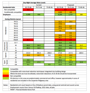
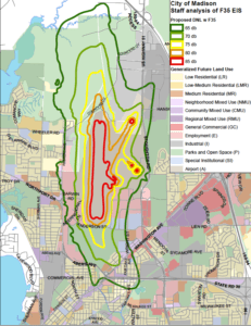
While zoning districts can allow a multitude of uses, the districts’ primary permitted use type (ie residential, commercial, industrial, etc.) was compared to FAA land use compatibility recommendations to determine the overall level of land use impact. FAA defines land uses as either compatible, not compatible or conditionally compatible with noise mitigating construction techniques. In the modeling of both the existing and proposed sound contours, the only area receiving the not compatible designation is the mobile home park on Packers Avenue just west of Dane County Regional Airport, which contains 312 units per City of Madison property data.
Nearly 1,200 residential units and 175 acres of residentially zoned land area are added to one of the conditionally compatible designations. This should not, however, be interpreted as the homes being uninhabitable as has been discussed by some in the community. It’s not uncommon for residential units to be within the 65 db contour, particularly in older cities and metro areas were the airport is relatively centrally located. This is the case with other airports in the region including Chicago O’Hare, Milwaukee and Minneapolis Saint Paul. It’s not surprising that staff’s estimation of residents impacted is different from what is discussed in the EIS, the Air National Guard did not utilize City property databases. With regard to the number of impacted housing units, the two estimates are relatively similar, though.
Health Concerns
Health consequences associated with noise exposure are dependent on the duration of exposure, intensity
(decibel level), and how often a population is exposed. Health impacts associated with long term exposure to noise levels similar to those expected from the F35s include: sleep disturbance, decreased school performance, increased levels of stress, hearing impairment, annoyance, hypertension, and heart disease. As described below, FAA funding restricts funding for sound mitigation to permanent structures and would presumably not be applicable to the mobile home park on Parkers Avenue, which contains 312 units per City of Madison property data. In addition, this funding would not be applicable to residential units and structures lying just outside the 65 db DNL contour lines, which include subsidized housing units, the Madison College campus and Hawthorne Elementary School. A broader spatial consideration of noise exposure impact and consequences should be considered to protect these vulnerable populations.
Potential Sound Mitigation
Airports around the country have participated in the voluntary 14 CFR Part 150 Noise Compatibility program discussed by the EIS. This can result in changes on and off airport property to mitigate sound exposure for properties contained within the 65 db DNL contour.
Actions may include modifications to airport operations, construction of sound walls, soundproofing for noise sensitive uses (including residential) and voluntary acquisition of property. Several of these actions were approved by the FAA for Milwaukee’s General Mitchell International Airport Noise Compatibility Program. The 65 db curve surrounding Milwaukee’s airport contains approximately 920 residential structures, many of which have since received soundproofing consisting of new doors and window.
Federally-funded soundproofing residential structures appears to be one of the most common techniques used by airports and associated communities that have applied for Noise Compatibility Program funding. The Part 150 Noise Mitigation Plan for Minneapolis Saint Paul includes some mitigation for residential units above 60 db, a lower noise level. The plan was approved by the FAA but was the result of litigation between the surrounding municipalities and the metropolitan airport commission, so it may not be transferable to Madison.
As Madison continues to see growth pressures and increasing housing costs, it’s important to maintain more affordable housing options such as those in the impacted area. Soundproofing may be the most appropriate migration option for impacted areas in Madison if Truax is selected for the F35 beddown, however other options do exist.
Burlington, VT chose to establish a voluntary acquisition program, where homes were purchased by the airport with federal funding and demolished. While this program did not result in any involuntary relocation, it removed a large amount of more affordable housing stock from an already tight housing market (145 homes were demolished since 1997). As part of an updated sound study associated with their arrival of F35s, focus has shifted away from demolition and towards soundproofing as elected officials and staff recognize that upgrading and preserving existing housing stock and neighborhoods have far greater resident and community benefits.
Soundproofing may not be an option for the mobile home park on Packers Avenue, which is in the current 65 db contour and would remain in the impacted area with the potential arrival of F35s. It appears the FAA considers mobile homes non-permanent structures and therefore does not allow soundproofing as a mitigation option.. A limited review of Part 150 Noise Mitigation Plans has shown options for mobile home parks are voluntary acquisition, purchase of sound easements over the property, and assisted relocation of the entire park to a site outside the 65 db contour. Madison’s adopted Future Land Use Plan recognizes the potential land use conflict, and if the site redevelops in the future it should shift from residential to an employment use.
While the EIS identifies 14 CFR Part 150 Noise Compatibility program as a potential path to mitigate noise exposure, it does not discuss the process, identify responsible parties or other relevant program details. Without this information, it’s not possible to understand the likelihood, timing and potential local costs associated with mitigating impacted properties. The draft EIS places the burden of identifying and understanding the program on those expected to provide comments; it would be far more helpful for the Air National Guard to expand this section and give Madison’s residents and elected officials better information on this program.
Staff has learned through discussions with the FAA that individual airports are responsible for initiating noise compatibility studies and mitigation programs. Since the airport is operated by Dane County and controlled by a board appointed by the County Executive, the City of Madison would have no official role in any potential noise mitigation study or program. The inability for the City to act on behalf of its residents and in the best interest of City-owned housing is a concern.
Environmental: Stormwater and Contamination
The EIS discusses construction activity needed if Truax is selected to receive F35s. The EIS indicates these changes would add a total of 1.7 Acres of impervious area. Added impervious surface would be near existing Air National Guard (ANG) facilities, outside the significant area of floodplain to the north runway 14-32 and west of the airport.
All construction activity would need to comply with Wisconsin standards including NR-116 (floodplain) and NR-151 (water quality and limited detention). Madison ordinances (MGO 37) have significantly more water quality and detention (flood control) requirements than the state standards, however there is limited ability of the City to enforce municipal standards as airports are exempt from compliance under Wisconsin TRANS 401. Based on the historic rain events experienced on the Westside of Madison and Dane County last year, and the well documented increase in frequency of intense storm events, Madison is currently working to revise its code to include additional stormwater requirements which would likely be in place if and when construction occurs.
One contaminant present on the Air National Guard base is per- and polyfluoroalkyl substances, or PFAs, a bioacumulative, toxic and persistent group of chemicals historically used in firefighting foams. The PFAs investigation on the base has yet to be completed and the WDNR has required additional investigation of soil, surface water, groundwater, and sediment both on and off the base. It is staff’s understanding that DNR’s request is not being acted upon, and the Department of Defense does not consider this a priority site for mitigation. Based on initial test results, PFAS-contaminated soil and groundwater contamination is widespread and its extent has not been fully defined. Under NR 700, a completed site investigation is required to define the nature and extent of PFAS contamination before remediation activities can be planned.
PFAs contamination are impacting City of Madison infrastructure, including Well 15, which was shut down out of an abundance of caution after test results showed elevated levels of PFAs. It will remain shut down except in an extreme water supply emergency until the state standards are established by the Department of Health Services. It is anticipated PFAs from the 115 Fighter Wing will continue to contaminate the City of Madison unit well #15 for decades to come.
The Department of Defense and the Air National Guard cannot safely and legally perform the planned construction activities without a complete site investigation that defines the extent and nature of PFAs contamination in soil and groundwater. The WDNR will require a materials management plan for any areas of the base impacted by construction, describing how excavated soil and dewatering will be managed. The 115 FW does not have enough information presently to do this. This investigation should be completed with full coordination with WDNR, and remediation of the contamination should take place concurrently in the event of a F-35 transition.
Other areas of concern include two former burn pits on the base. While the Air National Guard has taken responsibility for conducting the site investigation, no additional work has taken place yet. These should occur as soon as possible.
Questions regarding nuclear capacity:
The EIS does not address whether F35s based at Truax would carry nuclear weapons. F35s are designed to carry a wide range of combat weapons, and could eventually carry nuclear weapons. Staff has learned from the Air National Guard that if Truax is selected, the F35s arriving would not be nuclear capable and only units with a nuclear mission would be given the hardware necessary to carry nuclear weapons. The Madison Common Council has gone on record opposing the presence of nuclear weapons, first declaring Madison a nuclear free zoning in 1983 and reaffirming that as recently as August of 2019.
See the full statement for maps associated with this statement. F35 EIS staff analysis 9-10-19

